 |
| https://en.wikipedia.org/wiki/File:Map_Canada_political-geo.png |
This week's 52 Ancestors theme is Road Trip. A must have for any trip is a map. Map apps on your phone are great, but from experience I know they're useless if you go out of cell phone range.
I love old maps. Not only are they fun to look at, but they can help your genealogy research in so many ways. Library and Archives Canada has a huge collection of digitized maps on their website. To find them, you'll want to skip the databases and instead do an image search. First go to the main page of the Genealogy and Family History section of the website. Then you'll want to scroll down the page and click on Image Search.
 |
| http://www.bac-lac.gc.ca/eng/discover/genealogy/Pages/introduction.aspx#toc3 |
If you type in "maps" in the search engine, there are over 13,000 images. You'll definitely want to narrow things down a bit. I've played with types of maps and below are some examples of the types of maps you can find.
Cadastral Maps
These types of maps show property ownership. A really useful tool in your research. Not only can you find the location of your ancestor's land, but you can also see their FAN network (friends, associates and neighbours). Here's one showing the parish of Notre Dame de Quebec in 1879
Here's another showing part of Wentworth County, Ontario in 1859.
Fire Insurance Maps
If your ancestor lived in a city or town, you'll want to look at fire insurance maps. While these rarely show individual names, they are great for locating businesses. Even if your ancestor didn't own a business, they are still useful. By locating the street your ancestor was on, you can find the closest schools and churches. Look at the types of businesses around them, and you can get a sense of the community they were part of. Here's one showing a neighbourhood in Selkirk, Manitoba in 1910.
Here's another showing a neighbourhood in Calgary, Alberta in 1913
Railway Maps
Trying to find the route your ancestors took by rail? Railway Maps can help you track them. here's one of Western Canada in 1913
Canal Maps
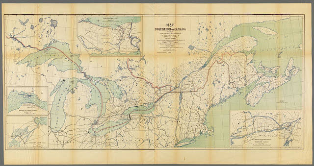
Before railways stretched across the continent, people traveled via canal routes. Here's a canal map for the Great Lakes and St.Lawrence in 1871.
Boundary Maps
As our country has grown and evolved, the provincial and territorial boundaries have as well. This is also true of counties, townships and other levels of municipal government. If you have an ancestor that seems to have disappeared out of government record collections, try looking at boundary maps. Depending on how close they lived to a border, they may have become part of another municipality.
Here's one showing the district of St. Francis, Canada East in 1863
Electoral Maps
One way to help find your ancestor in Voter's List is to look at maps of Electoral Districts. These can change several times over the years. Here's one from 1924 for Kings County, Prince Edward Island.
Industry Maps
Lastly, there are some specialized industry maps in their collection. If your ancestor was part of the mining industry, you might like to look at one like this from 1897 in British Columbia
Or this one from 1928 showing timber lands in Nova Scotia
The nice thing is that by right clicking on your mouse, you can download the images to your computer. As far as zooming in on sections, what I did was to click on the browser settings and zoom the whole screen. A word of warning though, some of the images become fuzzy if you zoom too close. You can also play with it once you've downloaded it to your computer. Take some time to explore their collection. They have everything from hand drawn to professional maps covering every corner of Canada and every time period


No comments:
Post a Comment