If you've never used Internet Archive, you should start. Starting way back in 1996, this wonderful sites allows libraries and institutions around the world to upload materials to the site for FREE. According to their about page, this virtual library now holds:
- 330 billion web pages
- 20 million books and texts
- 4.5 million audio recordings (including 180,000 live concerts)
- 4 million videos (including 1.6 million Television News programs)
- 3 million images
- 200,000 software programs
I like to regularly check on there to see what they've got relating to Canadian history and genealogy. I'm always finding something new. Genealogical Societies are jumping on the bandwagon too. They have been digitizing material and uploading to Internet Archive. One notable project has been the digitization of Toronto City Directories by the Toronto Branch of the Ontario Genealogical Society (now known as Ontario Ancestors). To date they have digitized most directories from 1833 to 1969. They have a chart on their website with direct links to the digitized directories here. Check with your local society to see if they've been uploading to Internet Archive. If they haven't, speak to the leadership about starting a project to do so.
But back to maps. The drawback to Internet Archive is that because of the sheer volume of information available, it will take some searching to find what you want. You don't want to be too specific, but you also want to try and weed out as much as you can on the first go. For instance, I typed in "Canada Maps" and got 2966 results. I typed in "Newfoundland Maps" and got 148 results. I typed in "Newfoundland Land Maps" and got 16 results, but they may not be what I'm looking for. And it all depends how the uploads been tagged for the search engines. When I typed in "Atlantic Canada Maps" I got 132 results. Some pertained to Newfoundland and didn't come up in the searches using "Newfoundland". As you can see, you'll have to play around a bit.
Now some of these various results were maps. But some of the results were also voice recordings, videos, reports, non fiction books and novels. These other results can be interesting to look at too. But if you only want to focus on one thing, then your next step is to use the filters on the left side bar. Here's a screenshot of the results from the search term "Canada Maps".
 |
| https://archive.org/search.php?query=Canada%20Maps |
Now if I filtered to just images, I get 65 results. But, not all of them are Canada specific maps.
 |
| https://archive.org/search.php?query=Canada+Maps&and[]=mediatype%3A%22image%22 |
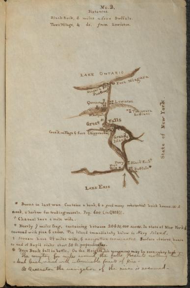
Now when I filtered to just texts, I found some interesting results. One was called Six manuscript maps showing places on Lake Ontario in southern Canada, the Niagara River and along the St. Lawence River. This was six hand dawn maps that were later included in a 1823 book called Travels through part of the United States and Canada in 1818 and 1819, volume 2, by John M. Duncan. What makes these manuscript maps so exciting is the notations at the bottom of each one. Here's a screen shot of map 2:
And here's a close up of the notations for map 2
Did you have an ancestor that fought in Flanders? Here's a map that is just one of many in the book Canada in Flanders (Vol 1) by Sir Max Aitken, with a preface by A. Bonar Law and an introduction by Sir Robert Borden.
As a side note, while I was flipping through pages I noticed many individual soldiers named. It's worth a look into the whole book.
I decided to filter by collection. I chose the collection Canadian Municipal Collection (Cities and Towns). I chose the rather dry sounding RESIDENTIAL AREAS GREATER WINNIPEG - PRELIMINARY REPORT, published in 1948. There's some rather interesting maps in there:
Judging from the report, Winnipeg had a housing crisis in the post WWII years. Included in the report are pictures of government housing areas. This report is a nice insight into the problems people had with adequate housing in post war Winnipeg.
Finally, here's a map from a pamphlet enticing wholesalers to come to Saskatoon. The map from the 1911 publication was made by the Saskatchewan Board of Trade.
And of course there are the maps on Internet Archive that one usually searches for, such as topographical and fire insurances maps. But what I really like about this site is that you will always find sources you didn't think to look at. Each I time I search on here I always find an unexpected source that leads me in a new direction.


Since no one in my family is interested in genealogy or family history I have been uploading my family stories to internet archive. It's free and anyone can do it.
ReplyDeleteI wish google search would include internet archive. I have lots of family history stories there, all my solved brick walls, but they don't show up in a google search for that name. I intended for my information to be available for free so that anyone could find it.
ReplyDelete